
News
Tuesday February 17 2026
New Strategic Planning System
Government Consults on Geography of England's New Strategic Planning System
The Government has launched a consultation on the proposed geographies for a new system of strategic planning across England. The consultation seeks views on where Spatial Development Strategies (SDSs) should be prepared to guide housing, infrastructure and environmental priorities at a sub‑regional level.
The consultation, published by the Ministry for Housing, Communities and Local Government (MHCLG) on 12 February, seeks views on the areas over which Spatial Development Strategies (SDSs) will be prepared. SDSs are intended to guide housing growth, infrastructure provision and environmental priorities across wider sub‑regional geographies.
Background to the reforms
The move follows the publication of the Government’s English Devolution White Paper in December 2024, which proposed mandatory strategic planning as part of a broader programme to accelerate housing delivery and strengthen cross‑boundary collaboration.
That commitment has since been given statutory backing through the Planning and Infrastructure Act, which received Royal Assent in December. The Act introduces a duty on combined authorities, combined county authorities, upper‑tier county councils and unitary authorities to prepare an SDS for their area. It also enables the creation of strategic planning boards where groups of authorities are required to work together.
Once adopted, SDSs will sit above local plans, with individual local plans expected to be prepared in general conformity with the strategic framework.
What the consultation proposes
Until now, the precise geographical coverage of SDSs had not been confirmed. The consultation proposes 40 SDS areas across England, grouped into four broad categories:
- SDSs based on existing devolution geographies, such as mayoral combined authorities;
- SDSs aligned with devolution priority programme areas;
- SDSs covering areas not currently aligned with existing devolution arrangements; and
- A final group of areas where no SDS geography is proposed, and where the Government is instead seeking views on appropriate boundaries
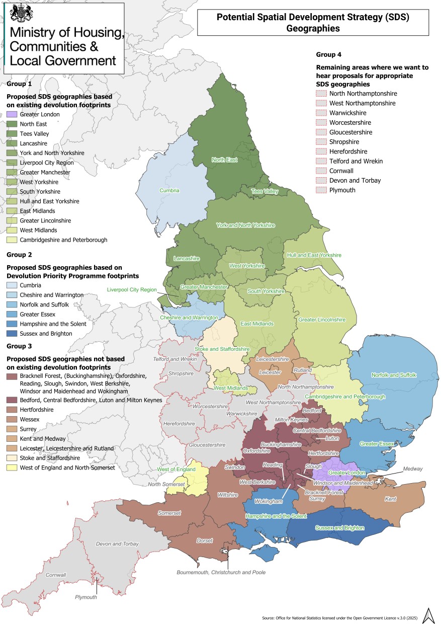
Above: MHCLG's Map of England showing the proposed SDS areas (Annex B of 'Areas for producing spatial development strategies')
In areas where there is already broad agreement between councils to work together, the Government has indicated it will move quickly to establish strategic planning boards and begin the formal statutory process. Where agreement is less developed, MHCLG is inviting alternative proposals to help inform final decisions.
Areas still to be defined
The consultation identifies eight areas where SDS boundaries have not yet been proposed, including Warwickshire, Worcestershire, Gloucestershire, Cornwall and Devon. In these cases, the Government has stated that devolution discussions have not progressed sufficiently to define a “sensible geography” for strategic planning, and further engagement is required.
Planning professionals have highlighted the importance of reading the consultation alongside the Government’s parallel announcements on expanding devolution, as the two agendas are closely linked.
Funding and next steps
MHCLG has confirmed that a funding package running to 2028–29 has been identified to support the preparation of SDSs. However, full funding allocations will not be confirmed until SDS geographies are agreed.
From March, the Government intends to begin funding those areas considered most ready to proceed, including all mayoral strategic authorities. Outside these areas, early funding will not in itself confirm the final SDS geography.
The consultation closes on 26 March, after which the Government will move to finalise SDS boundaries and establish strategic planning boards.
Why this matters
The reintroduction of strategic planning represents one of the most significant changes to England’s planning system in over a decade. By requiring councils to plan collaboratively across wider areas, SDSs are intended to address long‑standing challenges around housing delivery, infrastructure coordination and cross‑boundary growth.
For local planning authorities, developers and communities alike, the outcome of this consultation will shape how growth is planned — and where key decisions are made — for years to come.
DH Planning will continue to monitor the progress and outcome of the consultation, including the confirmation of Spatial Development Strategy geographies and the establishment of strategic planning boards. We will provide a further update once the Government published its response and sets out the next steps for implementation.
Author

Laura Jackson MA
Associate Director
Laura joined DHA in 2004 as part of our original Graduate intake. She holds a Bachelor of Science (Hons) Degree in Geography and Sports Science from Loughborough University, and an MA in Urban and Regional Planning at the University of Westminster. She is also a member of the RTPI.